The Netanyahu government’s recent threats to formally annex parts of the West Bank, instigated and supported by the Trump administration, have placed a rare spotlight on a deeply peripheral part of the Occupied Territories, the Jordan Valley.[2] Though pandemic mismanagement, economic crisis and normalization of relations with the United Arab Emirates have since pushed these plans far down the Israeli government’s agenda, the short-lived drama over annexation offers an opportunity to cast an overdue look at the eastern periphery of historic Palestine, of which the Jordan Valley forms a part.
Any division of the earth into regions entails both an emphasis on commonalities and an elision of differences; thus, there is usually something to be learned from redrawing the map. Israel/Palestine’s terminally indeterminate borders notwithstanding, the country can be carved up in a number of ways. The most common of these, of course, is the political division between pre-1967 Israel and the Occupied Territories. But Israelis also tend to divide the country latitudinally, with “the center”—which includes the major metropolitan areas of Tel Aviv and Jerusalem as well as the West Bank — separating “the north” (or the Galilee) from “the south” (or the Negev, Naqab).[3] For such a narrow sliver of land, a width-wise division may seem intuitive; but the country’s topographic zones actually run longitudinally, roughly from north to south. And topography is of decisive importance.
Slicing the country lengthwise is not an unprecedented act. As sociologist Salim Tamari shows in Mountain Against the Sea (2009), Palestinians have long maintained a cultural distinction between the country’s Mediterranean coast, seen as cosmopolitan and anomic, and its mountainous central spine, which is strongly associated with tradition and religiosity. Israelis make a homologous and historically affinate distinction between the secular-liberal “state of Israel,” centered on multicultural Tel Aviv, and the religious-nationalist “kingdom of Judah,” with its capital in conservative Jerusalem. But this juxtaposition of the littoral to the uplands leaves something out: the other side of the mountains, the part of the country that slopes towards the Dead and Red Seas. What, and where, is Israel/Palestine’s east?
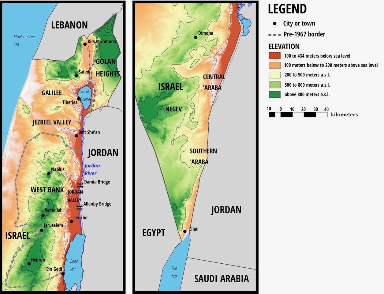
The drainage basins of the Mediterranean and Dead Seas are divided by a line which runs from the highest peak of the Galilee, Mt. Meron, through the Jezreel Valley, and through the ancient cities of Nablus, Jerusalem and Hebron. The line then veers southwest, crossing the town of Dimona and hugging the northern edge of the Ramon Crater. A small part of Israel, including the southern ‘Araba, drains into the Red Sea.
Topography and climate define the east. The drainage basins of the Mediterranean and Dead Seas are divided by a line which runs from the highest peak of the Galilee, Mt. Meron (Jabal al-Jarmaq), through the Jezreel Valley (Marj ibn ‘Amir), and through the ancient cities of Nablus, Jerusalem and Hebron. After passing through the South Hebron Hills, the line veers southwest, crossing the Israeli town of Dimona and hugging the northern edge of the Ramon Crater (Wadi Ruman).[4] East of the watershed the terrain drops, in places precipitously, into the depths of the Great Rift Valley, where the Jordan tumbles from the Lebanese highlands to connect the former wetlands of the Hula Valley to the Sea of Galilee and the Dead Sea, the lowest spot on earth at 430 meters below the Mediterranean. Due to the wind and rain shadows cast by the mountains to its west, the area sees little rainfall and is suffocatingly hot for long parts of the year.
Bordering and Marginalization
Despite its harsh climate, this zone only descended into its marginality as the colonial separation of Palestine from Transjordan hardened into a militarized border following the war of 1948. Heretofore it was easier to imagine the deep, narrow course of the Rift Valley as a fissure in the heart of the Levant, or even as the “grey sunken cunt” of the entire world, in the words of Irish novelist James Joyce (who never visited). After all, north of the Dead Sea the Jordan separates climactically similar zones which enjoy abundant rains in the winter and have housed closely linked sedentary populations for millennia. Under Ottoman rule, for example, the West and East Banks of the Jordan were tied together by ecological complementarity and close economic ties. Nablus’s longstanding soap industry depended not only on the olive oil produced in its immediate hinterland, but also on the alkaline ash (qilw) of the barilla plant, gathered and burned in the Balqa’ region in today’s Jordan.[5] Indeed, for parts of its history, the Ottoman district of Jabal Nablus encompassed ‘Ajlun and Salt, the major towns of this region.[6]
The Rift Valley itself is divided into the fertile and (until recently) well-watered basin of the Jordan, north of the Dead Sea, and the hyper-arid ‘Araba which stretches from its southernmost point to the northeast tip of the Red Sea. For centuries, the alluvial lands of the ghor around the river have been farmed by the eponymous ghawarna—often stigmatized for their dark skins, “foreign” origins and supposedly primitive way of life[7]—as well as by semi-sedentary Bedouin, who farmed large tracts during the mild winters.[8] Even the much drier ‘Araba has been exploited for copper mining and winter pastures for thousands of years, with its springs sustaining important thoroughfares including the ancient Incense Route and the hajj road from Cairo to Mecca.[9] The oldest inhabited city in the world, Jericho, is within the Rift, as are other historically important urban centers as Tiberias and Scythopolis (Beisan).
The Rift became a border in two major phases. Following the War of 1948, Israel took control of its western side from Metula to Beisan in the north and from Ein Gedi to ‘Aqaba in the south, expelling masses of urban, rural and Bedouin Palestinians from their homes, often into the now Jordanian-controlled parts of the basin.[10] Jewish immigrants from around the Middle East were settled in the ancient cities of Safed, Tiberias and Beisan (renamed Beit She’an) in place of their Palestinian populations, as well as in industrial “development towns” established at its southernmost and northernmost points, Eilat and Kiryat Shmona. As in the rest of the country, fertile agricultural lands were handed out to the favorite children of the Zionist establishment, “labor settlers” organized in kibbutzim (communal settlements) and moshavim (cooperative ones) who had previously worked land purchased from Arab landowners. The division of the region’s Jewish population between a Mizrahi (Middle Eastern-origin) urban proletariat and an Ashkenazi (European-origin) agrarian bourgeoisie would eventually take on political coloring, as the former rallied to the opposition Likud party against the Labor establishment.
Then, in 1967, Israel occupied the remaining portions of mandatory Palestine and the Golan Heights, leading to a new wave of expulsions which almost emptied the latter of its Syrian population.[11] In the West Bank, Defense Minister Moshe Dayan applied a policy of “open bridges,” allowing residents access to Jordan through the Allenby (or King Hussein, or Karameh) and Damia passages which link Jerusalem to Amman and Nablus to Salt, respectively. But it was his rival Yigal Allon who made a greater impact on Israel’s Ostpolitik in the occupation’s first decade. The semi-official Allon Plan aimed to perpetuate direct Israeli rule along the eastern flank with a view to preventing the re-establishment of Arab territorial contiguity between West and East Banks, leading eventually to the closing of the bridge at Damia and severe restrictions on crossings at Allenby. Only after Likud came to power in 1977 was the Allon Plan replaced by the settlement strategy that dominates Israeli policy to this day, emphasizing the foreclosure of Arab contiguity not from west to east but rather from north to south, through the construction of “fingers” of suburban settlement closely connected to Tel Aviv and Jerusalem. The new head of the Ministerial Committee for Settlement, Ariel Sharon, explained that “a thin line of [agricultural] settlements along the Jordan would not provide a viable defence […] the answer was to build […] urban, industrial settlements on the ridges overlooking” the coastal plain.[12]
Large-scale ecological transformations compounded the economic marginalization of the Jordan basin. In the years following the 1948 War, Israeli authorities set about draining the wetlands of the Hula, north of the sea of Galilee, displacing their ghawarna and Kurdish-origin inhabitants.[13] The US-brokered Johnston Plan, which sought to enhance the utilization of water within the entire riparian basin, faltered when Israel insisted on its sovereign right to pull water out of the river’s basin by mechanical means.[14] The immense National Water Carrier completed in the mid-1960s made good on this claim by exporting massive quantities of water from the Jordan to urban centers and agricultural frontiers beyond the watershed; by 1977, the Carrier and other irrigation schemes had reduced the river’s outflow at exit from the Sea of Galilee by almost ninety percent.[15] In the occupied Jordan Valley, sharecroppers once watered locally marketed bananas with ample spring-water managed as customary common property. Today, they are being pushed out by Israeli settlers and Palestinian agribusinesses based in Nablus and Ramallah, both planting date palms for export. Ironically, the ability of the lucrative new crop to subsist on urban wastewater and alkaline water from the degraded aquifer has led to the extension of the cultivated area, putting even greater pressure on local resources and pushing former sharecroppers into precarious positions as seasonal laborers.[16]
Barracks in the Heat
The Israelis who followed the Allon Plan to found agricultural settlements in the ‘Araba, the Jordan Valley and the Golan in the 1960s and 1970s were united by a desire to renew the austere self-reliance of early Labor Zionist pioneers on a new frontier. Though their lands lie within Israel proper, occupied Palestinian and occupied Syrian territory respectively, and in quite disparate ecological zones, to this day these settlers maintain close social and kinship ties and a common political outlook. While the perennially depressed Mizrahi-majority “development towns” of the east vote consistently for Likud and its satellites, the agrarian settlements kept faith to the declining parties of the labor movement until recently, when they transferred their allegiance to centrist parties such as Benny Gantz’s Blue and White. (This may explain Gantz’s momentary enthusiasm for annexing the Jordan Valley, rather than other parts of the West Bank.) The overlapping class and ethnic tensions of the region and their ecological background are condensed in the current struggle over the ‘Asi Stream, which used to flow toward the Jordan through Beisan/Beit She’an. The water has long been diverted for fish pools by the neighboring kibbutz, Nir David, but it is the latter’s illegal monopolization of recreational access to the stream which recently exploded into a culturally charged political clash.
Despite the intensity with which such local dramas play to a national audience, the east remains economically as well as demographically marginalized. Israel/Palestine is densely populated, but urbanization is concentrated in the west and center; the east is home to only about 5% of Israel’s citizen population (352,000 people, including settlers in the Jordan Valley and Golan) and a similar proportion of the Palestinian population of the West Bank (about 140,000 people).[17] The Israeli population, still distributed according to the obsolete strategic logic of pacification through frontier settlement and economic development—long abandoned in favor of the suburban thrust into the mountains orchestrated by Sharon—relies heavily on sources of livelihood which are at once subsidized, extractive and precarious.
Perhaps the most extreme example of this is the Central ‘Araba, the region’s remotest section. In this hyper-arid zone, agriculture is possible only thanks to heavy state investment in water-drilling[18] and the labor of migrants from Thailand, who today make up about half of the local population. These disenfranchised migrants do all the difficult work of raising vegetables in the desert, earning sub-minimum wages while discreetly keeping out of sight and helping to maintain the semblance of a purely Jewish “labor settlement.”[19] Meanwhile, the ancient aquifers below the Wadi ‘Araba are depleted and contaminated by agricultural runoff,[20] casting doubt on the continued viability of human settlement in a zone that already suffered from extreme heat before the onset of global warming. Ironically, it was the fading strategic orientation of Israeli “frontier settlement” which first drew the attention of the Thai government in the 1980s, when the latter was embroiled in its own troubles on the Cambodian frontier. The now stable and profitable flow of migrants from the “far” east to this near one—today there are over twenty thousand Thai workers all over Israel—began as an exchange of colonial technologies, with training excursions for delegations of Thai officials quickly morphing into a guest-worker program.[21]
Formal annexation, if it ever comes, will not bring integration or prosperity to Israel/Palestine’s marginalized east. On the contrary: abrogation of the Israeli-Jordanian peace treaty, which such a move might trigger, would complicate farming along the fertile lands abutting the riparian border, while drawing unwanted attention to the provenance of the region’s produce, much of which is exported to the Muslim world. This is perhaps why the settlers of the Jordan Valley, supposedly the greatest beneficiaries of annexation, are decidedly cool about the possibility. Indeed, the likelihood of annexation is fading by the day—but so long as the Rift Valley is bisected by the militarized frontier of a paranoid garrison state, the adjacent zone seems condemned to live out its days as an open-air barracks, dependent on state patronage, the unsustainable extraction of resources, and the cheap labor of the poor and disenfranchised, abandoned to the heat of the day.
[1] The author would like to thank Basma Fahoum for her constant encouragement and feedback throughout the incubation of this article, and Eyal Goldstein for invaluable cartographic assistance. Thank you also to the Social History Workshop for permission to reprint; an earlier version of this article ran in Hebrew on 1 July 2020.
[2] “Jordan Valley” is an ambiguous term. In this paper I use it in the most common sense, referring to the part of the Jordan’s basin that lies within the occupied West Bank rather than the entire river valley.
[3] In The Conflict Shoreline, Eyal Weizman explores the consequences of a division of the country along the two hundred mm isohyet, defined by “the minimum amount of water necessary to cultivate cereal crops without artificial irrigation on a flat surface.” Weizman represents this curve as a faultline of conflict running through the entire Old World. It passes through Israel/Palestine from west to east from Khan Yunis to a point east of Hebron, then roughly north by northeast, crossing into Jordan “[s]everal dozen kilometers north of the Dead Sea.” Most of what I consider as “the east” is part of the so-called desert that lies south of the isohyet. See Eyal Weizman and Fazal Sheikh, The Conflict Shoreline: Colonization as Climate Change in the Negev Desert (Gottingen: Steidl, 2015), 9–11.
[4] A small part of Israel, including the city of Eilat and the southern ‘Araba, drains into the Red Sea, which is an extension of the Rift Valley. I include this region in my definition of the east.
[5] Beshara Doumani, Rediscovering Palestine: Merchants and Peasants in Jabal Nablus, 1700–1900 (Berkeley and Los Angeles: University of California Press, 1995), 201–5.
[6] Doumani, 30, 47.
[7] Edward E. Curtis IV, “The Ghawarna of Jordan: Race and Religion in the Jordan Valley,” Journal of Islamic Law and Culture 13, no. 2–3 (October 2011): 193–209.
[8] Andrew Shryock, Nationalism and the Genealogical Imagination: Oral History and Textual Authority in Tribal Jordan (Berkeley and Los Angeles: University of California Press, 1997).
[9] Piotr Bienkowski and Katharina Galor, eds., Crossing the Rift: Resources, Routes, Settlement Patterns, and Interaction in the Wadi Arabah (Oxford: Oxbow Books, 2006).
[10] Walid Khalidi, All That Remains: The Palestinian Villages Occupied and Depopulated by Israel in 1948 (Washington: Institute for Palestine Studies, 2006); Samer Alatout, “Hydro-Imaginaries and the Construction of the Political Geography of the Jordan River: The Johnston Mission, 1953–56,” in Environmental Imaginaries of the Middle East and North Africa, ed. Diana K. Davis and Edmund Burke III (Athens: Ohio University Press, 2011), 218-45.
[11] Tayseer Mara’i and Usama R. Halabi, “Life under Occupation in the Golan Heights,” Journal of Palestine Studies 22, no. 1 (1992): 78–93. Israel’s claim to the Golan is not recognized by the international community (the US excepted), and Palestinians do not consider it a part of Palestine. However, it has been integrated into the Israeli sphere of control, and hence I include it in my analysis.
[12] Quoted in Eyal Weizman, Hollow Land: Israel’s Architecture of Occupation (London ; New York: Verso, 2007), 80.
[13] Dan Rabinowitz and Sliman Khawalde, “Demilitarized, Then Dispossessed: The Kirad Beoduins of the Hula Valley in the Context of Syrian-Israeli Relations,” International Journal of Middle East Studies 32, no. 4 (November 2000): 511–30; Sliman Khawalde and Dan Rabinowitz, “Race from the Bottom of the Tribe That Never Was: Segmentary Narratives Amongst the Ghawarna of Galilee,” Journal of Anthropological Research 58, no. 2 (2002): 225–43.
[14] See Alatout, 218.
[15] Mauro van Aken, François Molle, and Jean-Phillipe Venot, “Squeezed Dry: The Historical Trajectory of the Lower Jordan River Basin,” in River Basin Trajectories: Societies, Environments and Development, ed. François Molle and Philippus Wester (Cambridge: IWMI, 2009), 20–46.
[16] Julie Trottier, Nelly Leblond, and Yaakov Garb, “The Political Role of Date Palm Trees in the Jordan Valley: The Transformation of Palestinian Land and Water Tenure in Agriculture Made Invisible by Epistemic Violence,” Environment and Planning E: Nature and Space 3, no. 1 (March 2020): 114–40.
[17] These numbers are based on a definition of “the east” as all areas under Israeli control east of the drainage divide, less the eastern parts of the urban centers which lie along the divide. In order to calculate the Israeli population, I used the Israel Central Bureau for Statistics’ division into “natural zones,” counting the following: Hula Valley, Eastern Upper Galilee, Eastern Lower Galilee, Hatzor, Kinarot, Beit She’an Valley, Harod Valley, Ramat Kochav, Hermon, Golan (Northern, Central and Southern), Dead Sea, ‘Araba, and Southern Mount Negev. Since this division does not include the West Bank, I added the settler populations of the Megilot and Arvot Hayarden Regional Councils. To estimate the Palestinian population, I aggregated the 2017 figures of the Palestinian Central Bureau for Statistics for the Tubas and Jericho Governorates, al-‘Ubaidiya and Za‘atra municipalities (Bethlehem Governorate), and ‘Arab al-Jahalin, al-Qubeiba, and al-Sawahra al-Sharqiya (Jerusalem Governorate).
[18] Ami Shacham, “Water in the ‘Araba,” in The Arava: Landscape, Nature and People in the Arava Valley, ed. Yair Giladi et al. (Ein Yahav: Arava, 2012), 216–31 [Hebrew].
[19] Matan Kaminer, “At the Zero Degree / Below the Minimum: Wage as Sign in Israel’s Split Labor Market,” Dialectical Anthropology 43, no. 3 (September 2019): 317–32.
[20] O Oren, Y Yechieli, J.K Böhlke, and A Dody, “Contamination of Groundwater under Cultivated Fields in an Arid Environment, Central Arava Valley, Israel,” Journal of Hydrology 290, no. 3 (May 25, 2004): 312–28.
[21] Matan Kaminer, “By the Sweat of Other Brows: Thai Migrant Labor and the Transformation of Israeli Settler Agriculture” (PhD Dissertation, Ann Arbor, University of Michigan, 2019), 37–45; Yahel Kurlander, “The Marketization of Migration – On the Emergence, Flourishment and Change of the Recruitment Industry for Agricultural Migrant Workers from Thailand to Israel” (Haifa, University of Haifa, 2019) [Hebrew].