In the early hours of 8 March 1930, a spring storm dumped torrential rain on the Suez Canal cities of Isma‘iliyya and Port Sa‘id.[1] The rain fell quickly and the subsequent flooding caused widespread damage across Isma‘iliyya due to the city’s inadequate stormwater drainage system. A network of storm drains and sewers did exist, but was located primarily in the “European Quarter” of the town, where almost all infrastructure and general investment in the built environment had been concentrated since it was founded in 1862. In the so-called “Arab Quarter” the homes were built of brick and mud, and not masonry like in the European part of town, which left the former susceptible to devastation in the event of a natural disaster. Inhabited primarily by Egyptian families who had migrated to the city for employment with the Suez Canal Company, the Arab neighborhood on 8 March was, thus, flooded with rainwater that had no place to go and left nearly a dozen homes destroyed or unlivable.[2] I use this event to draw attention to the linkages between the built environments of the canal cities and their natural environments, which constantly asserted themselves in the urban space. Further, the juxtaposition of the so-called “Arab” and “European” sections of town sheds light on the unevenness, and environmental racism, of infrastructural development.[3] Additionally, this unevenness helps problematize the narrative of the Suez Canal Company as the dispenser of modernity through access to water and infrastructure; this highlighted by the inability of the SCC to create a unified and equitable urban built environment.
My research is a comparative examination of the Egyptian port cities of Port Sa‘id, Isma‘iliyya, and Suez (with Port Tewfik).[4] Looking at the three cities together demonstrates that each of the towns and their natural and built environments developed very differently. Where the SCC had complete control of the landscape and the rights to build infrastructure, it began to install a sewerage network quite early on; this was the case in the entirely new town of Port Tewfik (or Terre-plein).[5] In Port Sa‘id and Isma‘iliyya, the dual system of municipal governance shared between the SCC and the Egyptian-Ottoman state meant that building a unified and connected system of sewers and water infrastructure was uneven and rather delayed. Beyond even the dual system of governance, however, was a hierarchy based on race that influenced where administrators erected urban technologies of water, drainage, and sewerage, even in Port Tewfik.
In the neighborhoods inhabited primarily by Egyptians and Arabs, building and infrastructure standards were subpar and connections to the citywide network were slow and late, highlighting the disparity between European residences and Arab spaces. That is why an event like the flooding on 8 March 1930 is an important example as it points to the ways in which the French company saw the Arab section of Isma‘iliyya, and of all the towns, as an afterthought. The laying of infrastructure across the city and building strong masonry structures was not of concern to the European officials. It was only when the inadequacies of the infrastructural system affected the entire town that the SCC were forced to make changes. Thus, using a framework common to studies in Science and Technology Studies (STS) and urban infrastructural histories—Fredrik Meiton’s work on electricity in Palestine is an excellent example—I use infrastructure as a means to further explore social and political histories in the canal cities.[6] While they appeared to be homogenous in design, not least because the SCC tried to create uniform blocks and facades above ground, when you dig below the surface to the subterranean and go into the intimate domestic spaces of the toilet, the unevenness of development leaps out at the observer.
Stepping back, environmental history, water histories, and studies on water infrastructure in Egypt have been primarily focused on the Nile Valley. For example, Alan Mikhail in his monograph Nature and Empire in the Ottoman Empire looked at the ways in which the Nile floods were managed through a complex relationship between the Ottoman rulers of the province and the local residents who maintained the fields, ditches and land. In a more contemporary sociological study, Jessica Barnes highlights the systems (both bureaucratic and physical) at work in irrigation management in rural Egypt. My research, by contrast, connects environmental, urban, architectural, and technological histories to investigate the larger project of the Suez Canal Company, moving the focus away from the Nile as the only water body central to the existence of Egyptian urban environments.[7] This included the building of the Suez Canal water-way and a freshwater canal system that connected to the Nile waters, multiple stations along the waterway, two new major cities, and a new port south of Suez on the Red Sea. While this work is a reorientation geographically, from the Nile Valley to the Suez Canal region, it is also, crucially, a reconceptualization of how the urban environment is studied. As such, this essay serves as an addition to the growing and fluid interdisciplinary fields of environmental history and STS by linking the environment and materiality of the Suez Canal cities and the uneven development of water and sewerage infrastructure therein. This is similar to the call towards an “infrastructural turn” in Middle East studies. We have already seen some rewarding work on the Cairo water system in the early twentieth century by Shehab Ismail and across Middle East studies there is new work being done on historical issues related to infrastructure and politics.
Creating a uniform physical and natural environment and system along the entire length of the Suez Canal enabled its builders and others to imagine the canal and its many ports and stations as components of a larger single project. Part of what made the environment uniform for the SCC was the creation of gares, a “station” or “siding,” every five to six miles along the canal where ships could dock for a period to allow other ships to pass by. Each station was regularized with a water-tower containing fresh water, trees, and other plants, and in some cases a garden connected to the main station house.[8] These stations were situated between the rigole de service (freshwater canal), and the seawater channel, allowing connections to both as a means of receiving water, materials, and goods from other towns. The packed sand and sediment that lined the rigole was also planted with shrubbery and trees from the Suez Canal Company’s plant nursery in Isma‘iliyya. Acacia, tamarisk, and eucalyptus trees created a uniform line of vegetation along the rigole and helped to keep the narrow channel protected from debris.
This design was an important part of the reimagining of the environment along the canal’s route. Reeds and other similar plants, shrubs, and trees were either grown in nurseries in Egypt or imported from other parts of the world to be planted along the both the seawater and freshwater canals; for the most part, botanists and urban designers used these particular plants because of their heartiness and ability to survive with little water.[9] Tamarisk trees were also planted along the expanded rigole, which became the Abbassieh Canal in the 1890s. Shrubs were the ideal plant for the seawater canal, as they protected it from erosion and provided greenness in the sand, while the tamarisk tree with its protective cover kept the fresh waterway clean. Each type of plant also served to etch an aesthetic design upon an infrastructural project that changed, reshaped, and disciplined the natural landscape. The landscaping of the canals was closely monitored and discussed in the transit company’s meetings, and recorded in its minutes.[10] Photographs document the plants’ growth in intervals of months, and make visible the land on which these plantations were developed. In the Suez Canal Company papers, chief administrators, engineers, and health experts, discussed the viability of various plants and trees. The inclusion of such images and discussions in company reports highlights their recognized importance in these types of large-scale infrastructural projects that produced a new, physical “second nature” layer on the terrain—one that was man-made.[11]
The construction of the Suez Canal changed the imagery of the desert that Ferdinand de Lesseps—French diplomat and canal supporter—depicted in his initial survey of the land into one of lush towns and freshwater.[12] This was best exemplified through the urban plans. Central to the plans was the etching out of green spaces, which were prioritized for the European sections of towns. Difficulties arose in Port Sa‘id because of its distance from freshwater; this made growing private gardens or building large urban gardens expensive and troublesome. Even so, the Place de Lesseps represented the symbolic watering of the desert. With a water well in the middle and lush plant life surrounding it, the Place demonstrated to all those who passed through it both the Suez Canal Company’s project and its power to water the cities.
Studying the materials that made the square and land in Isma‘iliyya especially green and verdant helps us to understand the power of water and infrastructure and the ways in which it can delineate the hierarchy between the European and the Egyptian populations—the colonizer and the colonized. The desert was no longer a meddlesome zone but could bloom into a new life, albeit only through the introduction of freshwater. The Biblical underpinnings of this environmental imagining of the Suez Canal have been thoughtfully analyzed by Lucia Carminati.[13] Yet, it was the infrastructural additions, such as the Water Works in Isma‘iliyya and the construction of the Sweet Water Canal from the Nile—first through Zagazig and then directly from the Khalīg just northeast of Cairo—which made the project of greening the lands and cities alongside the canal much easier. Water was now controlled and moved from the Delta into the freshwater canal to feed the growth of the towns and provide drinking water for the residents, but not in an even fashion. How and when you received these services in the towns was determined by where you lived and your ethnicity. Across the three cities, offices of the canal company, company property, and the homes of their chief employees had interior bathrooms added significantly earlier than in the neighborhoods and homes in the Arab quarters. This discrepancy also played out in the design of the land plots. Spaces for gardens were prioritized and access to water included in the plan for the European quarter of town. Yet, the need for similar green spaces in the neighborhoods where Egyptians workers returned after a long day at the canal appeared to have been neglected in the plans. This stood in contrast to the SCC’s narrative of being simply a connection between the two ancient seas, albeit one which changed the zones of transportation and introduced new forms of sea life from the Red Sea into the Mediterranean. The squares and lands of the two towns—Port Sa‘id on the Mediterranean Sea and Isma‘iliyya at the center of the canal on Lake Timsah—were intricately connected not just to each other, but also to the materials that were moved and molded to create their physical spaces and to the populations who either had full access or minimal connection to the expanding urban infrastructural grid.
Finally, the opening story of the 1930 flood is an example of an extreme breakdown of the infrastructural system in Isma‘iliyya and the damage to property that resulted from uneven access to infrastructural and built systems in the towns along the Suez Canal. This was in stark contrast to the attempts of the company to create a unified urban landscape and infrastructural network for transportation, sewerage, and water. The unified aesthetic along the freshwater canal, the sea-water canal, and her cities, as developed by the SCC, falls apart as one peels back the layers of the urban environment to their core. Planting gardens and lining streets and canals with trees and shrubs hid the racial disparity in access to water and sewers across all sections of town. But it is that core, where the connections between the natural environment and infrastructure begin, shedding new light on how ethnic and social hierarchies were etched into the urban environment through access to water and sewerage networks.
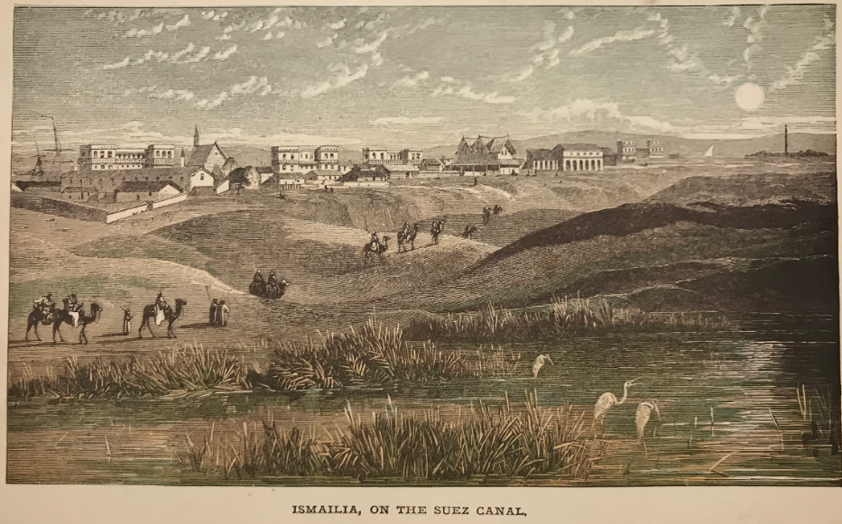
Figure 1 Ismailia, on the Suez Canal. (Author’s Personal Collection)[14]
Early illustration from an unknown source—probably a book—detailing the building of the Suez Canal and the cities. This image is a powerful example of the way in which the materiality of the natural environment is depicted as the outskirts of the new town. Animals, wildlife, water, and fauna are intrinsically linked to the development here of Isma‘iliyya. Conjuring up imaginings of a return from the wilderness this illustration can be seen within the larger projects’ goal: that through bringing water to the “desert,” or in this highly-salinated marshlands, that the Suez Canal Company was returning the land to some point in the biblical past.
Acknowledgments: I would like to thank Lucia Carminati, who read an early draft and provided valuable feedback. It is supportive and inspiring to have a colleague who is also interested in the project of telling the stories of the people who lived along the canal and the histories of the cities. It is also a strong indicator of the collaborative process of writing that this piece has really transformed with the assistance of Jadaliyya’s editors Camille Cole and Danya al-Saleh, as well as a number of anonymous readers who really pushed me into important directions and helped me make my arguments more accessible. Nothing is done in solitary.
[1] Archives Nationales du Monde du Travail in Roubaix, France (ANMT) 1995 060/4376, March 30, 1930, Services Techniques, Domaine-Eaux No. 4064.
[2] Ibid.
[3] Borrowing the term “environmental racism” from urban sociology and work like that of Mike Davis’ City of Quartz (New York: Vintage Books, 1992) I use the idea to highlight the ways in which the spatial was organized by ethnicity and infrastructural works in the towns were prioritized in the European sections.
[4] Port Tewfik was first called Terre-Plein, but was later renamed for Khedive Tewfik in the late 1870s. Nicolas Michel, “La Compagnie Du Canal de Suez et l’eau Du Nil (1854-1896),” in L’isthme et l’Égypte Au Temps de La Compagnie Universelle Du Canal Maritime de Suez (1858-1956), ed. Claudine Piaton, Bibliothèque Générale (Institut Français d’archéologie Orientale Du Caire) 48 (Le Caire: Institut français d’archéologie orientale, 2016), 273–203.
[5] Part of this goes back to the original concession agreed to in 1858 that gave the SCC the rights to dig the channel, cultivate the land along the channel, and build the necessary infrastructure and port facilities adjacent to the canal.
[6] Aditya Ramesh and Vidhya Raveendranathan, “Infrastructure and Public Works in Colonial India: Towards a Conceptual History,” History Compass 18, no.6 (2020).
[7] Mohamed Gamal-Eldin, “Cesspools, Mosquitoes and Fever. An Environmental History of Malaria Prevention in Ismailia and Port Said, 1869–1910,” in Seeds of Power: Explorations in Ottoman Environmental History, ed. Onur İnal and Yavuz Köse (Winwick: The White Horse Press, 2019), 184-207; Mohamed Gamal-Eldin, “Cities of Sand: Reshaping the Environment, Building Towns and Finding Modernity in the Isthmus of Suez 1856-1936,” (Ph.D. diss., New Jersey Institute of Technology, 2020).
[8] ANMT 1995 060/5499 Diagram and sections of the Suez Canal.
[9] This also occurred in other colonial environments, like Algeria and the United States of America. The sharing of biological specimens, like the movement of populations as colonizers/occupiers, allowed colonizers to reshape the landscape. See Diana Davis, The Arid Lands: History, Power, Knowledge, (Cambridge: MIT Press, 2016).
[10] Alexandria Library Digital (suezcanal.bibalex.org), al-Lagnā al-Dawlayyā, Etat des Plantations November 5, 1901.
[11] William Cronon, Nature’s Metropolis: Chicago and the Great West. (New York: W.W. Norton, 1997).
[12] Ferdinand de Lesseps, The Suez canal; letters and documents descriptive of its rise and progress in 1854-1856. (London: King, 1876).
[13] Lucia Carminati, “Port Said and Ismailia as Desert Marvels: Delusion and Frustration on the Isthmus of Suez, 1859-1869,” Journal of Urban History 46, no. 3 (2020): 622–47.
[14] Found during an excursion in Melbourne, Australia while traveling with my wife. Exploring a store that sold antique books and maps I came across this detached lithograph that had been well preserved.